GEOTECHNICALENGINEERING1
FRESNO
HomeGeophysicsSeismic tomography (refraction/reflection)

Seismic Tomography (Refraction/Reflection) for Geotechnical Confidence in Fresno

Sound ground. Sound decisions.

LEARN MORE

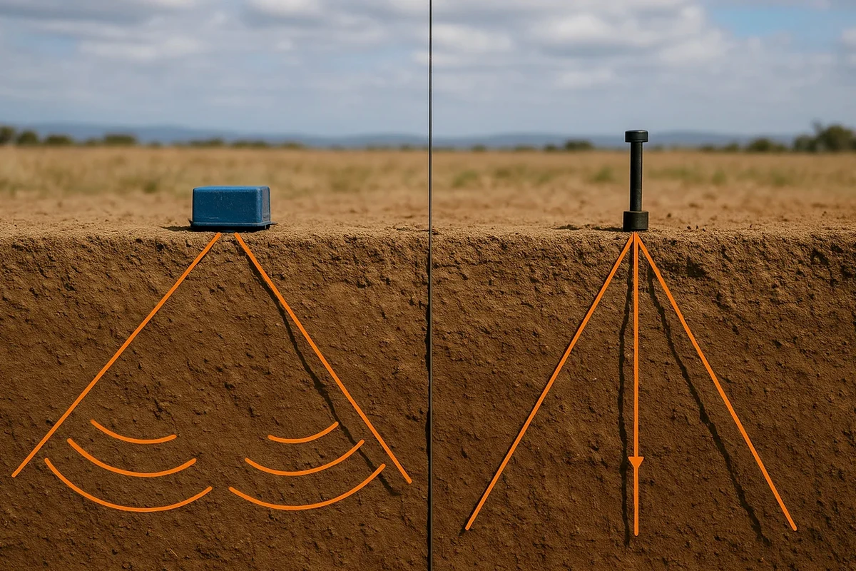
Fresno's growth from an agricultural rail stop to a sprawling Central Valley hub brought serious geotechnical questions to the surface. The city sits on deep alluvial basins fed by the Kings and San Joaquin rivers, with sediment layers that can vary from dense gravels to compressible silts within a single city block. Many older downtown structures near the Fulton Mall were built long before modern site characterization existed, leaving builders today with a complicated legacy. When a project's structural loads or seismic demands go beyond the reach of a test pit, we turn to seismic tomography—both refraction and reflection—to image what lies 30, 50, or even 100 feet below grade. The method uses controlled surface sources to map P-wave and S-wave velocity contrasts, revealing bedrock topography, buried channels, and velocity gradients that directly inform ASCE 7 site classification and foundation depth decisions across the city.

A seismic tomography line across a Fresno site turns a guess about bedrock depth into a measured velocity contour—that is the difference between a conservative overdesign and a foundation you can actually justify to the plan checker.

Our service areas

Methodology and scope

One thing we learned early on in Fresno is that the shallow water table east of Highway 99 creates a velocity inversion that kills a standard refraction survey if you do not set it up correctly. That subtle clay layer saturated at 12 feet masks the true bedrock velocity, so we run longer spreads and pair refraction with reflection acquisition to bypass the low-velocity trap.

The reflection method images impedance contrasts at depth using common-midpoint stacking, while refraction delivers a continuous P-wave velocity model of the vadose zone and upper bedrock. Together they give us a calibrated subsurface cross-section, not just a single line of numbers. We process the data with tomographic inversion algorithms that update the velocity model iteratively, converging to a solution that honors first arrivals and reflected phases simultaneously. This dual approach proves essential in Fresno's alluvial setting, where a MASW survey can complement the tomography with shear-wave velocity profiles for site class determination. For projects near the San Joaquin River bluffs, the cross-check with a slope stability analysis becomes critical once the tomography reveals any paleochannel scarp hidden beneath younger fill.
Seismic Tomography (Refraction/Reflection) for Geotechnical Confidence in Fresno
Technical reference — Fresno

Local considerations

The risk profile changes sharply depending on which side of the Fresno-Clovis boundary you are building on. West Fresno and the Highway 99 corridor sit on younger, looser alluvium with higher compressibility and a shallow water table that amplifies ground motion. Move northeast toward Clovis and you encounter older alluvial fans with denser, partially cemented sediments that transmit seismic energy differently. A developer who assumes uniform site class across a parcel near Herndon Avenue without running a seismic line can end up with one corner of the building on Class D and another on Class C—a differential settlement and spectral acceleration mismatch that the structural engineer did not budget for. Seismic tomography maps those transitions before the first yard of concrete is poured, giving the design team a velocity model they can feed directly into ground response analysis and foundation stiffness calculations.

Need a geotechnical assessment?

Reply within 24h.

Email: contact@geotechnicalengineering1.com

Applicable standards

ASTM D5777-18 (seismic refraction), ASTM D7128-18 (seismic reflection), ASCE 7-22 (site classification and seismic design parameters)

Technical parameters

ParameterTypical value
Typical survey depth (refraction)30 to 100 ft, depending on spread length and source energy
Typical survey depth (reflection)50 to 300+ ft, suited for deeper basin imaging
Source typeAccelerated weight drop or sledgehammer on plate, selected by penetration target
Geophone spacing5 to 20 ft, optimized for target resolution
Recorded phasesP-wave first arrivals + reflected phases on 24- or 48-channel seismograph
Velocity model output2D P-wave tomography, optionally converted to S-wave via Poisson ratio
ResolutionTypically 5-10% of target depth, refined through iterative inversion

Frequently asked questions

How much does a seismic tomography survey cost for a typical Fresno commercial lot?

For a standard commercial parcel in the Fresno area, a combined refraction/reflection survey typically runs between US$3,000 and US$4,660, depending on the number of lines, spread length, and whether we need to mobilize a weight drop source for deeper penetration. We quote the survey after reviewing your site plan and project depth requirements so the number reflects real field conditions.

What does seismic tomography tell me that a standard SPT boring does not?

An SPT gives you blow counts at discrete points; tomography gives you a continuous 2D velocity cross-section between those points. In Fresno's alluvial setting, that means you can trace a buried channel or a lateral velocity change across the site instead of guessing what happens between two borings spaced 50 feet apart.

Can you run a seismic line on a paved site without tearing up the asphalt?

Yes, we plant geophones on pavement using coupling plates and wax or gel, and we use a weight drop on a rubber pad to avoid damaging the surface. The survey leaves the asphalt intact, and we restore any small plate marks after acquisition.

How long does a seismic tomography survey take and when do I get results?

Fieldwork for a two-line survey on a typical Fresno lot takes one day with a two-person crew. We process the data using tomographic inversion and deliver a velocity cross-section with interpretation notes within five to seven business days, often sooner if the project schedule is tight.

Is seismic tomography reliable for mapping the water table depth?

It is one of the most reliable surface geophysical methods for water table mapping because saturated sediment produces a sharp P-wave velocity increase—typically from around 1,500 ft/s in dry alluvium to 5,000 ft/s or more when saturated. In Fresno, where the water table can sit within 10 to 15 feet of the surface, the refraction method picks that contrast clearly.

Location and service area

We serve projects across Fresno and surrounding areas. More info.

View larger map